Pakistan ranks among the most climate-vulnerable countries, frequently experiencing flash floods, glacial lake outburst floods (GLOFs), and hill torrents that endanger lives, livelihoods, and critical infrastructure. Despite the promise of IoT-based monitoring, flood-prone regions often lack access to early warning systems due to remote locations and the absence of traditional communication infrastructure. The IntelliWarn initiative addresses this gap by developing and deploying scalable, low-cost, IoT-based Flood Early Warning Systems (FEWS) for off-grid, high-risk areas. The system leverages solar-powered sensors, LoRaWAN and GSM technologies, and custom communication networks to deliver real-time alerts even in areas without electricity or mobile coverage. Initial deployments in Swat, Namal, and five high-risk sites in Sindh demonstrated the system's effectiveness, delivering upstream flood warnings and enabling community response. Developed by the Lahore University of Management Sciences (LUMS) in collaboration with the Aga Khan Agency for Habitat (AKAH), the initiative integrates community preparedness and local ownership into the system’s design. It serves as a replicable model for disaster resilience, combining technological innovation with inclusive, data-informed emergency planning.
3rd PLACE
SDG Impact Award Award
IntelliWarn: A scalable and Scaling Up Low-Cost, IoT-Based Flood Early Warning
3rd PLACE SDG Impact Award Award
Lahore University of Management Sciences (LUMS), Aga Khan Agency for Habitat – Pakistan. - Pakistan
"Connecting the Last Mile with IoT: First Alerts for the Most Vulnerable "
Have a say and vote for this entry to win the People's Choice Award!
500 points per vote
Provide your email address and click on "vote". You will then receive an email that enables you to verify your vote by clicking on a link.
1500 points for each share/re-post; 500 points for each like
This entry has not provided any social media links for community voting.
Summary
Key People

Dr. Abubakr Muhammad
Associate professor of electrical engineering, the founding director of the Centre for Water Informatics & Technology (WIT), and the lead for NCRA National Agricultural Robotics Lab at LUMS.
Lahore University of Management and Sciences

Dr. Naveed ul Hassan
Associate professor of electrical engineering Syed Babar Ali School of Science and Engineering
Lahore University of Management and Sciences

Dr. Talha Manzoor
Dr. Talha Manzoor serves as an Assistant Professor at the Centre for Water Informatics and Technology (WIT) at LUMS, where he is also the Associate Director of Operations.
Lahore University of Management and Sciences

Ali Akbar Abbas
Business Development Manager, Centre for Water Informatics and Technology, LUMS
Lahore University of Management and Sciences
Acknowledgements
This project was made possible with the generous support of the APNIC Foundation under the ISIF Asia Ian Peter Grant for Internet and the Environment 2022. We are grateful for their commitment to enabling inclusive, scalable, and locally grounded innovations that address environmental and connectivity challenges in underserved regions.
We also thank the Aga Khan Agency for Habitat (AKAH) - Pakistan, for their invaluable collaboration in facilitating site access, community coordination, and supporting field implementation.
Images
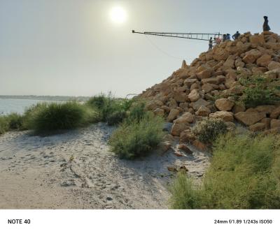
A wide perspective showing the elevated boom of the water-ranging system extending over the Indus River. Deployed in collaboration with the Aga Khan Agency for Habitat (AKAH), the structure supports our in-house water-ranging sensor.
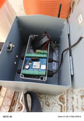
A glimpse inside our completely self-designed legacy water-ranging sensor based on GSM IoT, enabling real-time water ranging telemetry.
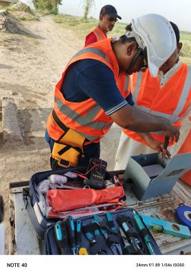
A member of the LUMS technical team performs on-site troubleshooting and calibration of a GSM-enabled flood sensor during fieldwork in Sindh. Backed by over a decade of field deployment experience, the team ensures reliable performance even in remote and challenging environments.
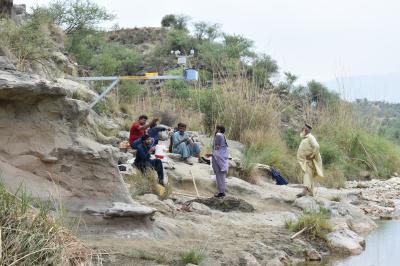
Field team pauses after a full-day installation of a flood detection sensor in Namal. The site, known for flash floods, now hosts upstream monitoring equipment to support early warning and community safety.
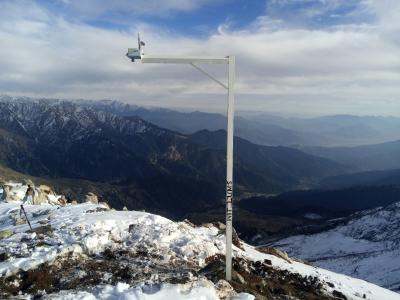
Deployed snow depth and weather sensor overlooking Swat Valley. The station enables real-time data collection for forecasting snowmelt and flood risk in downstream communities.
IMPACT STORY
Impacting lifes
The IntelliWarn initiative has demonstrated tangible and meaningful impact across Pakistan’s most flood-prone and infrastructure-deficient regions. Through pilot deployments in diverse terrains from the mountainous regions of Mansehra and Swat to the agricultural plains along the Indus River in Sindh, the system has proven its reliability, adaptability, and geographic flexibility.
Critically, two real flood events were successfully detected during system development and field testing in Swat and Namal. These early detections provided 10–15 minutes of advance warning in fast-flowing catchments, a crucial lead time that can support life-saving decisions. In Sindh, systems deployed at five sites enabled real-time alerts using a combination of GSM and LoRaWAN technologies, covering over 15 kilometers from the nearest GSM signal and functioning independently through solar power.
Beyond immediate alerts, the system’s architecture supports national-level scalability. Pakistan’s GLOF-II project, for instance, has identified the need for over 400 monitoring sensors across 20 districts an objective that IntelliWarn modular, open-standard design is well suited to meet. The platform has also demonstrated versatility in adjacent domains such as water resource monitoring and digital agriculture.
Community engagement has been a cornerstone of the project. Collaboration with the Aga Khan Agency for Habitat (AKAH) ensured that technical deployments aligned with local disaster preparedness efforts. Partner organizations and local authorities have reported improved response capabilities and expressed strong interest in scaling the model. Additionally, the project has begun to catalyze a regional innovation ecosystem by involving local researchers, technicians, and vendors, contributing to sustainable development and capacity building.
LEARNINGS
Lessons learned
Open Standards & Interoperability
Prioritize systems that follow open standards, support integration via APIs, and comply with FAIR data principles. Avoid vendor lock-in.
Fit-for-Context Design
Focus on cost-effective, modular solutions that work off-grid, use solar power, and offer multiple connectivity options (LoRa, GSM, mesh).
Scale Over Precision
In disaster contexts, timely and scalable data—even if less precise—is far more valuable than high-accuracy systems that don’t scale.
Local Capacity & Value Chain
Train local youth and engage regional vendors to sustain deployments. A robust local technical ecosystem is essential for long-term success.
CBDRM Integration
Embed tech within community-based disaster response. Ensure alerts are usable, understood, and acted upon by local actors.
FUTURE PLANS
What's coming?
IntelliWarn is entering a strategic scale-up phase to extend its reach into fully off-grid, high-risk regions. Upcoming deployments include glacier-linked early warning systems (EWS) in Gilgit-Baltistan and Chitral, hill torrent alerts in Dera Ghazi Khan and Balochistan, and flash flood detection systems in Swat. LoRaWAN-based weather stations will also be integrated to support national agencies like PMD and NDMA.
The initiative will pilot deployments in international settings Nepal, Myanmar, and Kyrgyzstan to demonstrate adaptability across diverse geographies and risks. All systems are designed to be open-source, vendor-free, and locally maintained to ensure long-term sustainability.
Ongoing collaboration with AKAH, NDMA, PMD, and IRP will help validate functionality across multiple contexts, while community training and gender-inclusive engagement will foster local ownership and institutional trust.
